Skip to content

Saturday Update: The Front Range Forecast: Snow Totals and warming

In Brief:

Snow totals and a warm up beings.
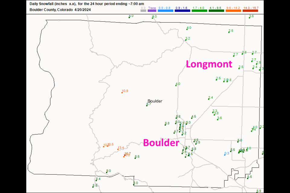
Saturday update:

That storm way overproduced!  I thought we'd see an inch or so. We almost saw 3 inches in Longmont. Boulder got a whopping 5-8 inches. The GFS from an earlier updated pretty much got it right.

After this, we warm up!  Later next week we may see an extended period of rain and showers.  More later!

figure3u_04202024
Figure 3 update: the CoCoRaHS snowfall total as of Saturday AM.

End Saturday update.

Friday update:

Light rain and snow showers have been falling for a day. The rainfall picks up Friday afternoon and evening and changes over to snow. We should have about 1/4th to 1/2 inch of water by the time it is done (more in the Foothills). But snowfall should only be in the 1-3 inch range at the lower elevations (with 3-6 inches in the nearby mountains).

We warm up to 60's and 70's next week.  Next Friday is our next change of moisture.

figure1_04192024
Figure 2 update: the 4 day snowfall (10:1) forecast map from the GFS and weather5280.com

End Friday update.

Tuesday update:

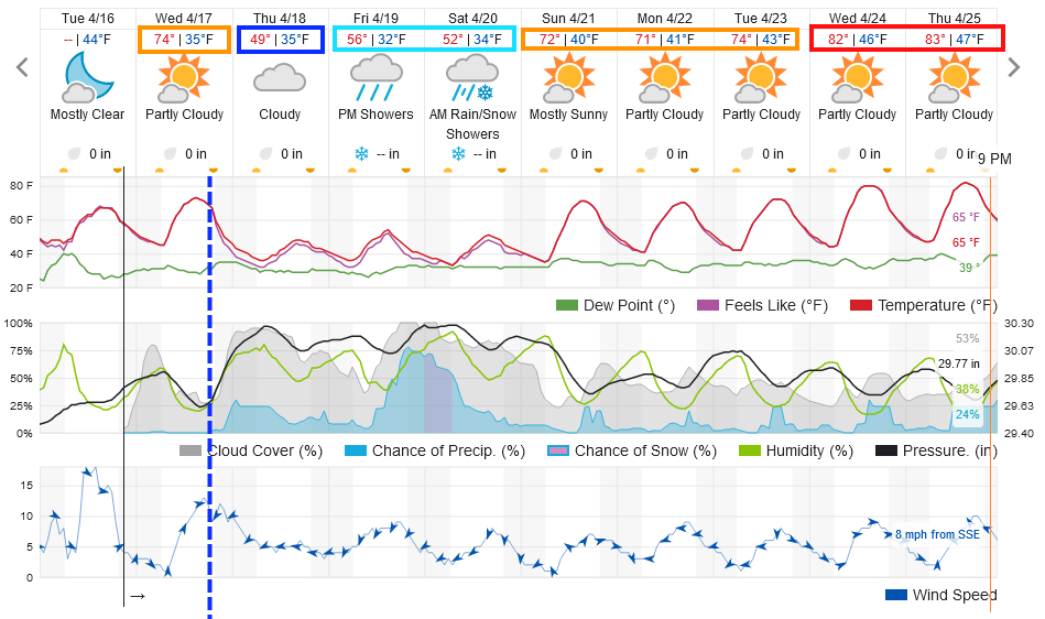
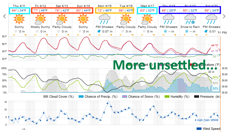
We warm to the 70's one more time before a strong cold front sweeps the low lands Wednesday evening.  Some rain chances return with chilly damp weather. Our biggest rain chances arrive Friday PM into Saturday midday (Figure 1). There is a chance the rain changes to snow in the early morning hours but I'm not thinking much will build up, except on lawns, in Longmont.

We warm after that to the 80's by midweek. Hello Spring.

figure1u_04162024
Figure 1 update: the 10 day graphical forecast for Longmont from weatherunderground.com

End Tuesday update.

The Forecast Discussion:

A very powerful ridge is on its way to bring our first 80 degree highs since October 20, 2023. The weekend will feel great!

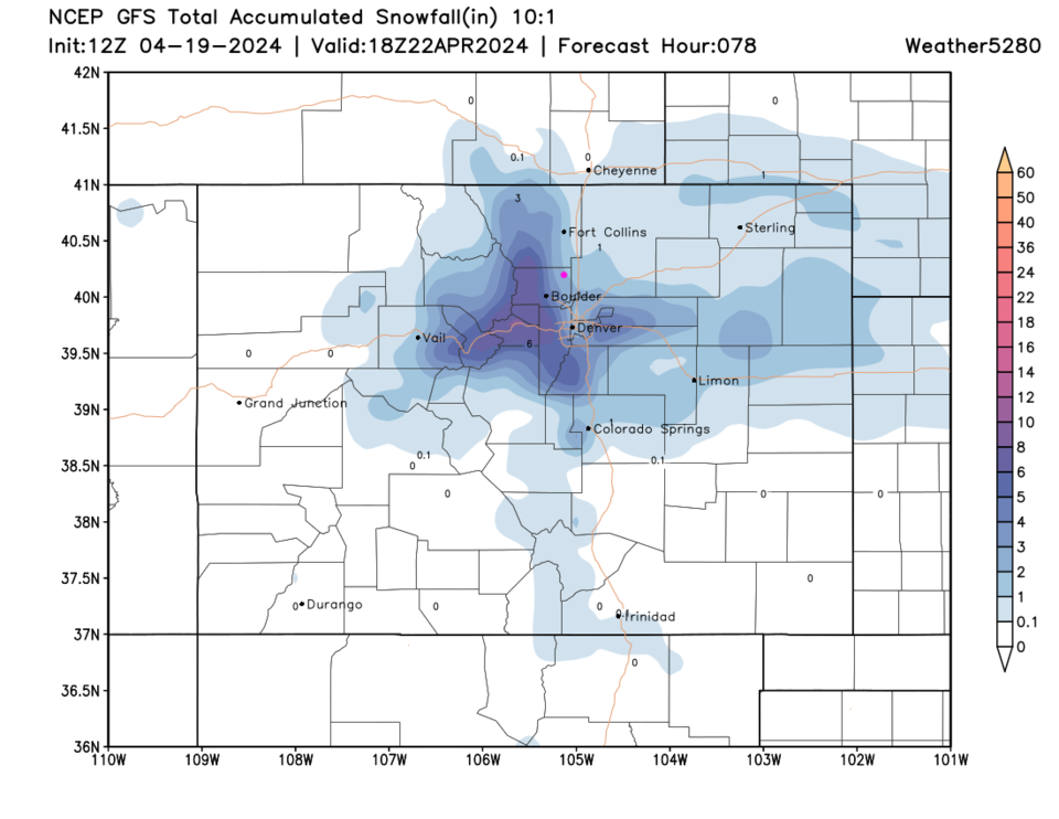
A series of troughs then begin to sweep the state next week cooling us down to below normal temperatures with rain and rain/snow mixes at the lower elevations (Figure 1).

figure1_04112024
Figure 1: the 10 day graphical forecast for Longmont from weatherunderground.com

The Long Range Forecast:

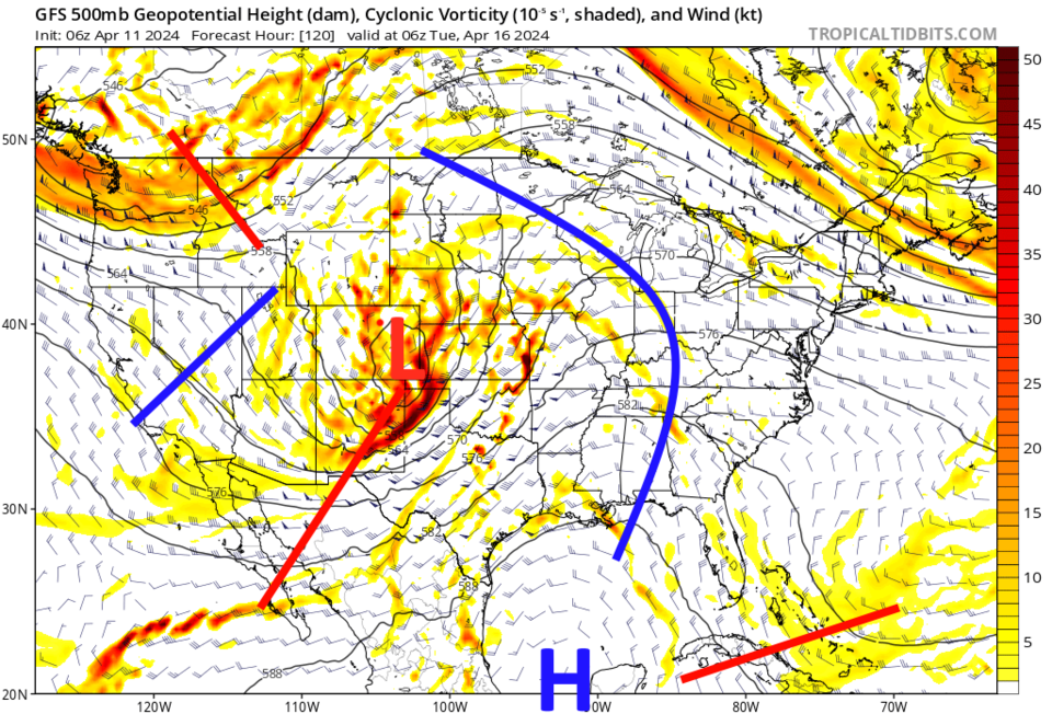
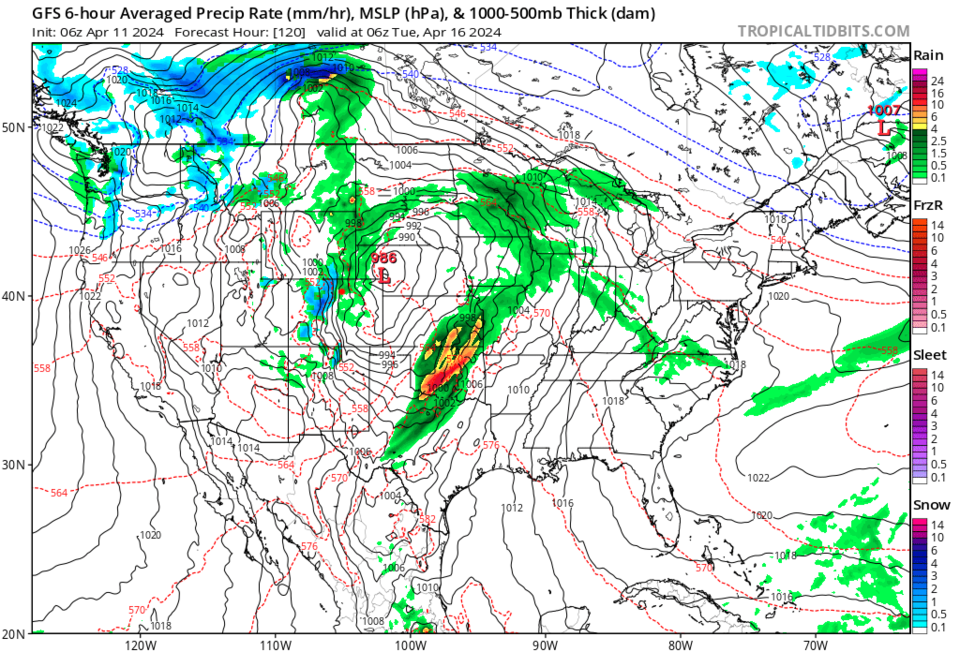
The trough is a pretty strong one and we should see winds pick up again (Figure 2). The mountains will see snow while the Plains will see rain (Figure 3).

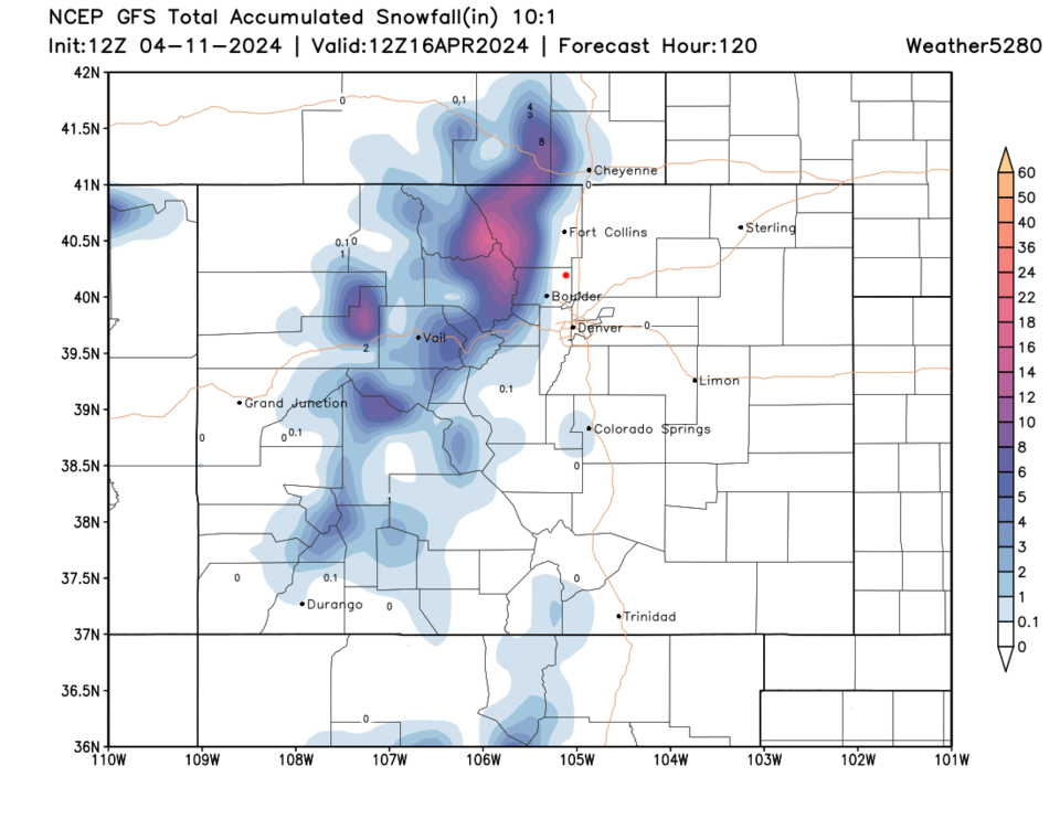
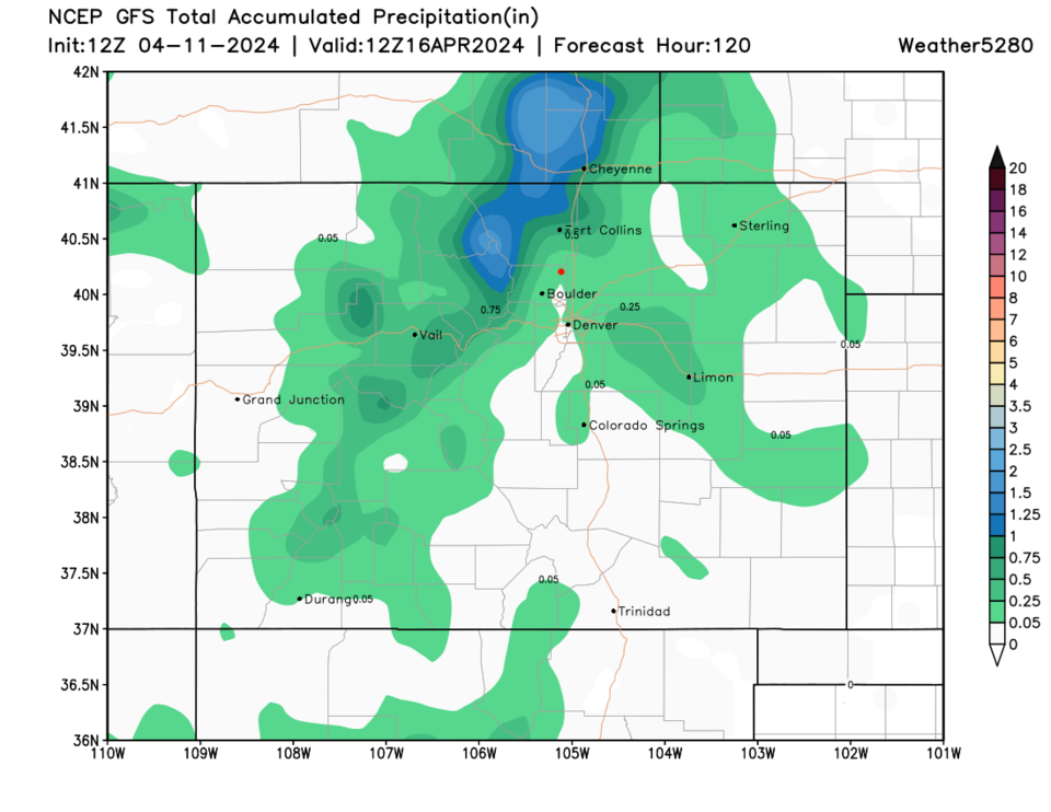
From this first system, spots in the northern mountains may pick up to a foot of snow, but the low lands get skipped (Figure 4). Rain will occur north and east of Denver but should only come in at around 1/10th of an inch to a lucky 1/2 inch in places.

More later!

figure2_04112024
Figure 2: the 500mb upper air forecast GFS model for midnight before Tuesday.
figure3_04112024
Figure 3: the surface forecast GFS model for midnight before Tuesday.
figure4_04112024
Figure 4: the 5 day 10:1 snowfall forecast from the GFS and weather5280.com
figure5_04112024
Figure 5: the 5 day precipitation forecast from the GFS and weather5280.com


About the Author: John Ensworth

John Ensworth used to work from Longmont as the PI for the NASA through the IGES (The Institute for Global Environmental Strategies). He now teaches technology, algebra, astronomy, meteorology, film school, and Lego robotics to middle/high school.
Read more


Comments


Current Weather

Sunny

Sunny

71°F

UV Index
10 Very High
Pressure
29.84 Rising
Visibility
6 miles
Dewpoint
45 °F
Humidity
39%
Wind
SE 2.7 mph
Gust
6.6 mph
Wind Chill
71 °F

Hourly Forecast

Today
1 PM
73°F
Partly sunny
Today
2 PM
74°F
Partly sunny
Today
3 PM
73°F
Partly sunny
Today
4 PM
71°F
Partly sunny
Today
5 PM
70°F
Partly sunny w/ t-storms
Today
6 PM
68°F
Partly sunny
Today
7 PM
65°F
Partly sunny
Today
8 PM
63°F
Partly sunny
Today
9 PM
60°F
Partly cloudy
Today
10 PM
57°F
Partly cloudy
Today
11 PM
54°F
Partly cloudy
Tomorrow
12 AM
53°F
Partly cloudy

7 Day Forecast

Partly sunny w/ t-storms

Monday

74 °F

Partial sunshine with a thundershower in spots


Partly cloudy

Monday Night

46 °F

Partly cloudy


Thunderstorms

Tuesday

78 °F

Considerable cloudiness with a thunderstorm in the afternoon; gusty winds and small hail can accompany any thunderstorm


Thunderstorms

Tuesday Night

47 °F

A thunderstorm in spots in the evening; otherwise, mainly cloudy


Thunderstorms

Wednesday

63 °F

Rather cloudy and cooler; a passing shower in the morning followed by a thunderstorm in the afternoon


Partly cloudy w/ t-storms

Wednesday Night

42 °F

Partly cloudy with a couple of showers and a thunderstorm


Intermittent clouds

Thursday

75 °F

Pleasant and warmer with times of clouds and sun


Mostly clear

Thursday Night

44 °F

Mainly clear


Mostly sunny

Friday

77 °F

Mostly sunny and warmer


Clear

Friday Night

46 °F

Clear


Sunrise and Sunset

Sunrise
5:46 AM
Sunset
8:08 PM

Based on AccuWeather data