Skip to content

Mon Update: The Front Range Forecast: More warmth, little rain

In Brief:

Near record heat and little chance of rain.

Monday Update:

The great western ridge moves in again bringing back late season 80's for highs.  The normal high temperature is only 65F now - this is really warm. Records for these dates are still a bit warmer, in the mid to upper 80's. We see a hint of cool weather and showers about 9 days from now, but that can certainly change.

Stay tuned!

figure2_10162023
Figure 2 update: the 10 day graphical forecast for Longmont from weatherunderground.com

End Monday update.


Special Note:  

This Saturday morning, we'll have a partial eclipse of the sun peaking around 10:30am.  This eclipse will, at no moment, be safe to look at in ANY WAY except by certified eclipse glasses (undamaged and new) or a telescope with appropriate front end solar filtering.

I will be opening the Cherrywood Observatory for people to come look.  Please do not bring any viewing aids (like binoculars) or welder goggles.  To find my address and details, search for the Cherrywood Observatory eclipse on Nextdoor.  I hope to see you there.

Thur Update:

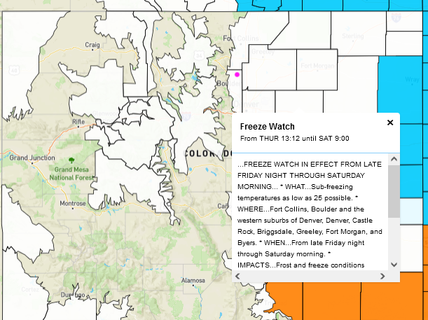
The low and storm are pulling away.  I received about 0.16 in of water yesterday and a trace or more today. The first freezing temperatures are headed in overnight tonight.  There is a freeze watch for I-25 cities and the eastern plains.  Cover those plants or bring them inside!

figure1u_10122023
Figure 1 update: freeze watch map from the NWS.

End Thur update.

The Forecast Discussion:

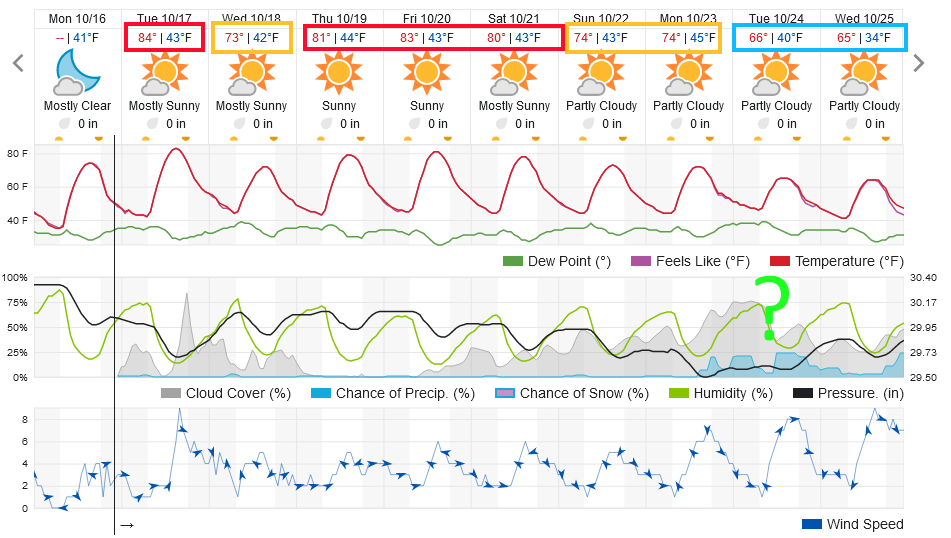
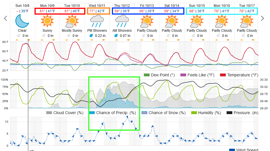
The ridge holds on for a couple more days. We'll see above normal temperatures into Wednesday morning (Figure 1). Afternoons get a bit breezier each day.

figure1_10082023
Figure 1: the 10 day graphical forecast for Longmont from weatherunderground.com

The Longer Range Forecast:

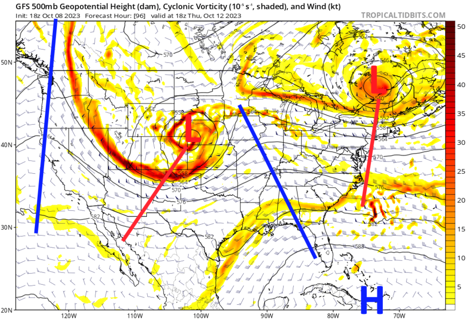
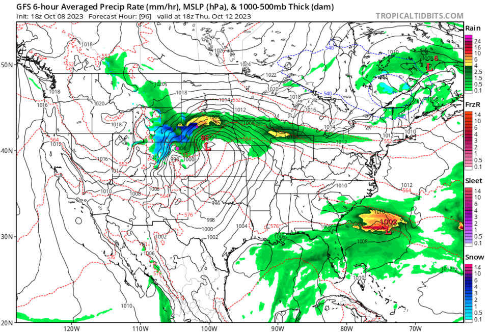
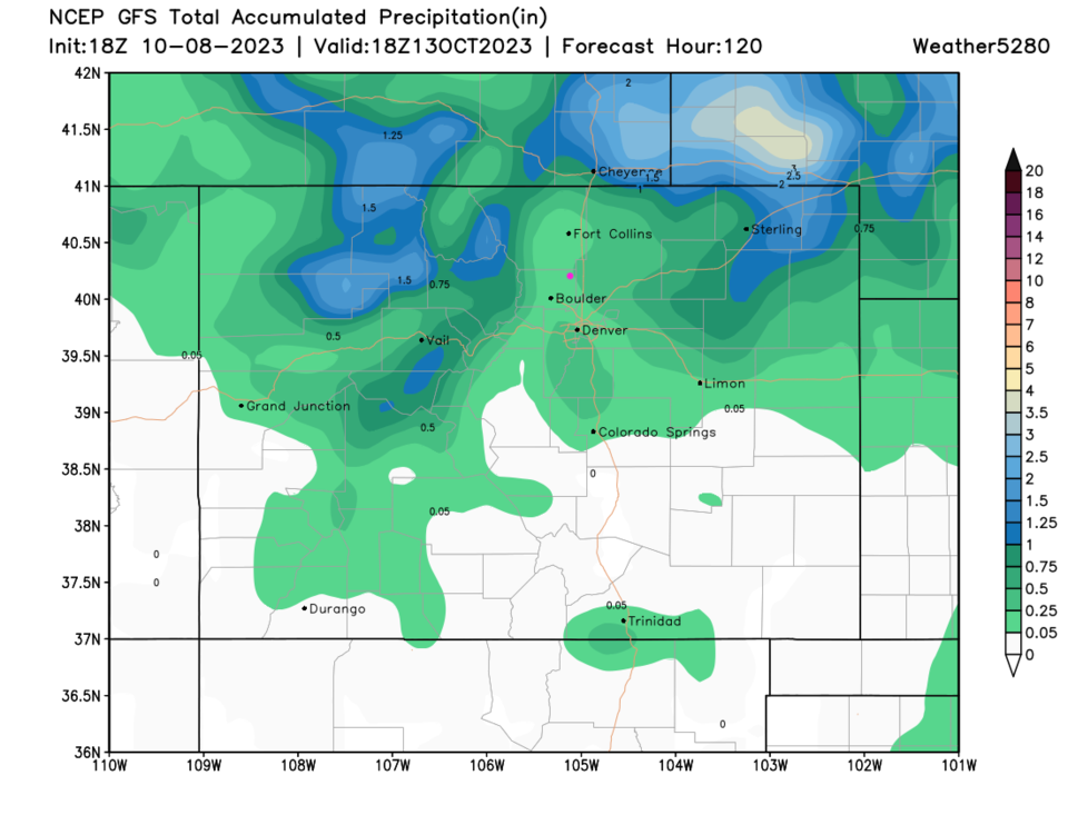
A healthy cut-off low rolls over Colorado Wednesday afternoon and Thursday. (Figure 2). At present, northern Colorado will see the precipitation, rain on the low lands, snow in the northern mountains (Figure 3). Rainfall amounts do look pretty light, though (Figure 4).

figure2_10082023
Figure 2: the 500mb upper air forecast map for Thursday noon from the GFS and tropicaltidbits.com
figure3_10082023
Figure 3: the surface 6 hour precipitation forecast map for Thursday noon from the GFS and tropicaltidbits.com
figure4_10082023
Figure 4: the 5 day precipitation total from the GFS and weather5280.com


About the Author: John Ensworth

John Ensworth used to work from Longmont as the PI for the NASA through the IGES (The Institute for Global Environmental Strategies). He now teaches technology, algebra, astronomy, meteorology, film school, and Lego robotics to middle/high school.
Read more


Comments


Current Weather

Cloudy

Cloudy

42°F

UV Index
1 Low
Pressure
30.23 Rising
Visibility
8 miles
Dewpoint
31 °F
Humidity
65%
Wind
SE 2.4 mph
Gust
5.2 mph
Wind Chill
42 °F

Hourly Forecast

Today
9 AM
45°F
Mostly sunny
Today
10 AM
49°F
Mostly sunny
Today
11 AM
53°F
Mostly sunny
Today
12 PM
55°F
Mostly sunny
Today
1 PM
59°F
Mostly sunny
Today
2 PM
61°F
Partly sunny
Today
3 PM
63°F
Partly sunny
Today
4 PM
64°F
Intermittent clouds
Today
5 PM
66°F
Intermittent clouds
Today
6 PM
64°F
Intermittent clouds
Today
7 PM
62°F
Intermittent clouds
Today
8 PM
59°F
Mostly clear

7 Day Forecast

Partly sunny

Saturday

66 °F

Not as warm with sun and some clouds


Mostly clear

Saturday Night

39 °F

Clear to partly cloudy


Mostly cloudy

Sunday

77 °F

Mostly cloudy and warmer; breezy in the afternoon


Mostly cloudy

Sunday Night

45 °F

Rather cloudy; breezy late


Windy

Monday

60 °F

Very windy; cloudy and cooler


Intermittent clouds

Monday Night

43 °F

Partly cloudy


Intermittent clouds

Tuesday

62 °F

Times of clouds and sun; windy in the afternoon


Partly cloudy

Tuesday Night

36 °F

Partly cloudy


Intermittent clouds

Wednesday

60 °F

Times of clouds and sun


Intermittent clouds

Wednesday Night

35 °F

Partly cloudy


Sunrise and Sunset

Sunrise
5:55 AM
Sunset
7:59 PM

Based on AccuWeather data